
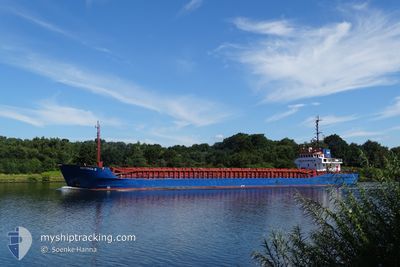
ANTONIA B
General Cargo
Current Trip
| Time Travelled | 1 day |
|---|---|
| Remaining Time | 4 h, 5 mins |
| Distance Travelled | 268.87 nm |
| Remaining Distance | 44.19 nm |
| AVG Speed | 8 Knots |
| MAX Speed | 12 Knots |
| AVG Wind | 7.3 knots |
| MAX Wind | 16 knots |
| MIN Temp | 0.6°C / 33.08°F |
| MAX Temp | 7.8°C / 46.04°F |
| Dybgang | 3.4 m |
| Position Modtaget | 1 m siden |
Current Position
| Longitude | 10.90381° |
|---|---|
| Latitude | 56.55412° |
| Status | Under way using engine |
| Fart | 9.9 Knots |
| Kurs | 329.8° |
| Område | Kattegat |
| Station | T-AIS |
| Position Modtaget | 1 m siden |
Info
Information
The current position of ANTONIA B is in Kattegat with coordinates 56.55412° / 10.90381° as reported on 2024-04-25 20:50 by AIS to our vessel tracker app. The vessel's current speed is 9.9 Knots and is heading at the port of AALBORG. The estimated time of arrival as calculated by MyShipTracking vessel tracking app is 2024-04-26 00:57 LT
The vessel ANTONIA B (IMO: 8919221, MMSI: 211100000) is a General Cargo that was built in 1990 ( 34 år gamle ). It's sailing under the flag of [DE] Germany.
In this page you can find informations about the vessels current position, last detected port calls, and current voyage information. If the vessels is not in coverage by AIS you will find the latest position.
The current position of ANTONIA B is detected by our AIS receivers and we are not responsible for the reliability of the data. The last position was recorded while the vessel was in Coverage by the Ais receivers of our vessel tracking app.
The current draught of ANTONIA B as reported by AIS is 3.4 meters
Weather
| Temperature | 6.8°C / 44.24°F |
|---|---|
| Wind Speed | 11 knots |
| Direction | 139° SE |
| Pressure | 1005.2 hPa |
| Humidity | 67.3 % |
| Cloud Coverage | 21 % |
Featured Company
Last Port Calls
| Port | Arrival | Departure | Time In Port |
|---|---|---|---|
| 2024-04-23 14:55 | 2024-04-24 12:21 | 21 h | |
| 2024-04-21 16:25 | 2024-04-22 13:39 | 21 h | |
| 2024-04-20 20:58 | 2024-04-21 10:16 | 13 h | |
| 2024-04-17 14:55 | 2024-04-18 13:21 | 22 h | |
| 2024-04-16 00:22 | 2024-04-16 13:00 | 12 h | |
| 2024-04-13 12:01 | 2024-04-15 10:21 | 1 d | |
| 2024-04-08 01:15 | 2024-04-08 13:43 | 12 h | |
| 2024-04-07 16:10 | 2024-04-07 16:13 | 2 m | |
| 2024-04-04 22:18 | 2024-04-06 13:20 | 1 d | |
| 2024-04-03 03:47 | 2024-04-03 16:19 | 12 h |
Last Trips
| Origin | Departure | Destination | Arrival | Distance | |
|---|---|---|---|---|---|
| 2024-04-22 15:39 | 2024-04-23 16:55 | 202.69 nm | |||
| 2024-04-21 12:16 | 2024-04-21 18:25 | 59.18 nm | |||
| 2024-04-18 15:21 | 2024-04-20 22:58 | 341.01 nm | |||
| 2024-04-16 15:00 | 2024-04-17 16:55 | 203.93 nm | |||
| 2024-04-15 12:21 | 2024-04-16 02:22 | 132.51 nm | |||
| 2024-04-08 15:43 | 2024-04-13 14:01 | 554.71 nm | |||
| 2024-04-07 18:13 | 2024-04-08 03:15 | 82.55 nm | |||
| 2024-04-06 15:20 | 2024-04-07 18:10 | 186.66 nm | |||
| 2024-04-03 18:19 | 2024-04-05 00:18 | 263.35 nm | |||
| 2024-03-25 18:19 | 2024-04-03 05:47 | 531.04 nm |
Events
| Tid | Hændelsen | Detaljer | Position / Dest | Info |
|---|---|---|---|---|
| 2024-04-25 09:53 | Ændre havområde | Danish part of the Kattegat Danish part of the Baltic Sea |
54.73115 / 10.76356
Kattegat
DKAAL
|
Fart: 10.8 kn Kurs: 19° |
| 2024-04-25 08:41 | Fundet i havområde | Danish part of the Baltic Sea |
54.56372 / 10.58898
Baltic Sea
DKAAL
|
Fart: 9.9 kn Kurs: 65° |
| 2024-04-25 07:23 | Ændre havområde | German part of the Baltic Sea German part of the North Sea |
54.45867 / 10.27400
Baltic Sea
DKAAL
|
Fart: 9.8 kn Kurs: 41° |
| 2024-04-25 06:29 | START Sejllads | 1.33 nm, South West of STICKENHΟRN SPORT |
54.36604 / 10.14321
DKAAL
|
Fart: 3.7 kn Kurs: 104° |
| 2024-04-25 05:57 | STOP Sejllads | 1.38 nm, South West of STICKENHΟRN SPORT |
54.36654 / 10.14017
DKAAL
|
Fart: 0.3 kn Kurs: 105° |
| 2024-04-25 00:29 | Status er ændret | Under way using engine Default |
54.12223 / 9.32884
DKAAL
|
Fart: 6.7 kn Kurs: 355° |
| 2024-04-25 00:12 | Status er ændret | Default Under way using engine |
54.09074 / 9.32493
DKAAL
|
Fart: 6.8 kn Kurs: 17.4° |
| 2024-04-24 22:03 | START Sejllads | 0.6 nm, South West of BRUNSBUETTEL |
53.89592 / 9.14802
DKAAL
|
Fart: 4.4 kn Kurs: 50° |
| 2024-04-24 21:30 | STOP Sejllads | 0.73 nm, South West of BRUNSBUETTEL |
53.89447 / 9.14525
DKAAL
|
Fart: 0.3 kn Kurs: 43° |
| 2024-04-24 17:28 | Dybgangen er ændret | 3.4 3.5 |
53.95047 / 8.62310
DKAAL
|
Fart: 6.7 kn Kurs: 128.5° |