
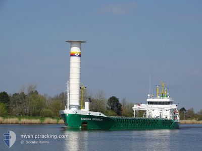
ANNIKA BRAREN
Cargo
Current Trip
| Time Travelled | 5 days |
|---|---|
| Remaining Time | 10 h, 14 mins |
| Distance Travelled | 1352.71 nm |
| Remaining Distance | 114.33 nm |
| AVG Speed | 9.2 Knots |
| MAX Speed | 13.8 Knots |
| AVG Wind | 12.5 knots |
| MAX Wind | 22.9 knots |
| MIN Temp | 1.6°C / 34.88°F |
| MAX Temp | 17.1°C / 62.78°F |
| Dybgang | 4.3 m |
| Position Modtaget | 4 m siden |
Current Position
| Longitude | 16.77564° |
|---|---|
| Latitude | 56.08426° |
| Status | Under way using engine |
| Fart | 10.7 Knots |
| Kurs | 54.5° |
| Område | Baltic Sea |
| Station | T-AIS |
| Position Modtaget | 4 m siden |
Info
Information
The current position of ANNIKA BRAREN is in Baltic Sea with coordinates 56.08426° / 16.77564° as reported on 2024-04-24 19:20 by AIS to our vessel tracker app. The vessel's current speed is 10.7 Knots and is heading at the port of MONSTERAS. The estimated time of arrival as calculated by MyShipTracking vessel tracking app is 2024-04-25 05:39 LT
The vessel ANNIKA BRAREN (IMO: 9849148, MMSI: 211302790) is a Cargo It's sailing under the flag of [DE] Germany.
In this page you can find informations about the vessels current position, last detected port calls, and current voyage information. If the vessels is not in coverage by AIS you will find the latest position.
The current position of ANNIKA BRAREN is detected by our AIS receivers and we are not responsible for the reliability of the data. The last position was recorded while the vessel was in Coverage by the Ais receivers of our vessel tracking app.
The current draught of ANNIKA BRAREN as reported by AIS is 4.3 meters
Weather
| Temperature | 3.3°C / 37.94°F |
|---|---|
| Wind Speed | 5 knots |
| Direction | 70° ENE |
| Pressure | 1008 hPa |
| Humidity | 67.5 % |
| Cloud Coverage | --- |
Featured Company
Last Port Calls
| Port | Arrival | Departure | Time In Port |
|---|---|---|---|
| 2024-04-18 02:55 | 2024-04-19 11:14 | 1 d | |
| 2024-04-11 05:39 | 2024-04-11 14:50 | 9 h | |
| 2024-04-05 22:05 | 2024-04-08 17:41 | 2 d | |
| 2024-04-02 02:43 | 2024-04-03 16:01 | 1 d | |
| 2024-03-30 02:25 | 2024-03-30 16:27 | 14 h | |
| 2024-03-27 03:40 | 2024-03-27 17:39 | 13 h | |
| 2024-03-20 05:30 | 2024-03-20 15:42 | 10 h | |
| 2024-03-18 19:51 | 2024-03-19 11:23 | 15 h | |
| 2024-03-12 05:18 | 2024-03-13 12:25 | 1 d | |
| 2024-03-06 04:45 | 2024-03-06 15:36 | 10 h |
Most Visited Ports (Last year)
| Port | Arrivals | |
|---|---|---|
| 18 | ||
| 15 | ||
| 15 | ||
| 15 | ||
| 9 | ||
| 6 |
Last Trips
| Origin | Departure | Destination | Arrival | Distance | |
|---|---|---|---|---|---|
| 2024-04-11 16:50 | 2024-04-18 04:55 | 1419.52 nm | |||
| 2024-04-08 19:41 | 2024-04-11 07:39 | 681.59 nm | |||
| 2024-04-03 18:01 | 2024-04-06 00:05 | 561.29 nm | |||
| 2024-03-30 17:27 | 2024-04-02 04:43 | 553.24 nm | |||
| 2024-03-27 18:39 | 2024-03-30 03:25 | 559.22 nm | |||
| 2024-03-20 16:42 | 2024-03-27 04:40 | 1242.25 nm | |||
| 2024-03-19 12:23 | 2024-03-20 06:30 | 224.63 nm | |||
| 2024-03-13 13:25 | 2024-03-18 20:51 | 1314.48 nm | |||
| 2024-03-06 16:36 | 2024-03-12 06:18 | 1289.89 nm | |||
| 2024-03-05 12:14 | 2024-03-06 05:45 | 225.31 nm |
Events
| Tid | Hændelsen | Detaljer | Position / Dest | Info |
|---|---|---|---|---|
| 2024-04-24 14:08 | Ændre havområde | Swedish part of the Baltic Sea Danish part of the Kattegat |
55.62272 / 15.34459
Baltic Sea
SEJAT
|
Fart: 10.7 kn Kurs: 62° |
| 2024-04-24 08:53 | Fundet i havområde | Danish part of the Kattegat |
55.03344 / 14.09403
Kattegat
SEJAT
|
Fart: 10.3 kn Kurs: 68.5° |
| 2024-04-24 08:14 | Fundet i havområde | Swedish part of the Baltic Sea |
54.99271 / 13.91109
Baltic Sea
SEJAT
|
Fart: 10.5 kn Kurs: 68.7° |
| 2024-04-24 01:05 | Ændre havområde | German part of the Baltic Sea Danish part of the Baltic Sea |
54.41402 / 12.11710
Baltic Sea
SEJAT
|
Fart: 10.1 kn Kurs: 86.7° |
| 2024-04-23 22:31 | Ændre havområde | Danish part of the Baltic Sea German part of the Baltic Sea |
54.51531 / 11.41540
Baltic Sea
SEJAT
|
Fart: 9.6 kn Kurs: 117.6° |
| 2024-04-23 20:07 | Ændre havområde | German part of the Baltic Sea Danish part of the Baltic Sea |
54.56113 / 10.76396
Baltic Sea
SEJAT
|
Fart: 10.7 kn Kurs: 83.8° |
| 2024-04-23 19:40 | Ændre havområde | Danish part of the Baltic Sea German part of the Baltic Sea |
54.55180 / 10.62796
Baltic Sea
SEJAT
|
Fart: 10.5 kn Kurs: 82.8° |
| 2024-04-23 18:22 | Ændre havområde | German part of the Baltic Sea German part of the North Sea |
54.45820 / 10.27368
Baltic Sea
SEJAT
|
Fart: 10.8 kn Kurs: 41.5° |
| 2024-04-23 17:36 | START Sejllads | 1.29 nm, South West of STICKENHΟRN SPORT |
54.36562 / 10.14601
SEJAT
|
Fart: 4.3 kn Kurs: 103° |
| 2024-04-23 16:57 | STOP Sejllads | 1.34 nm, South West of STICKENHΟRN SPORT |
54.36613 / 10.14288
SEJAT
|
Fart: 0.3 kn Kurs: 105° |