
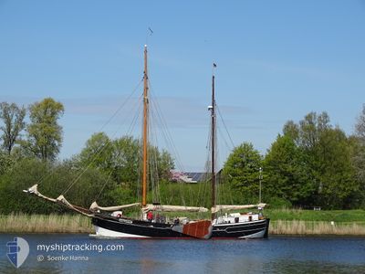
AMAZONE
Sailing Vessel
Current Trip
DE/KAP
| Time Travelled | 19 h, 19 mins |
|---|---|
| Remaining Time | --- |
| Distance Travelled | 2.99 nm |
| Remaining Distance | --- |
| AVG Speed | 3.9 Knots |
| MAX Speed | 4.5 Knots |
| AVG Wind | 11.9 knots |
| MAX Wind | 12.1 knots |
| MIN Temp | 5.2°C / 41.36°F |
| MAX Temp | 5.6°C / 42.08°F |
| Dybgang | 1.8 m |
| Position Modtaget | 18 h, 26 m siden |
Current Position
| Longitude | 9.93660° |
|---|---|
| Latitude | 54.65366° |
| Status | Under way sailing |
| Fart | 3.3 Knots |
| Kurs | 21.3° |
| Område | Baltic Sea |
| Station | T-AIS |
| Position Modtaget | 18 h, 26 m siden |
Info
Information
The current position of AMAZONE is in Baltic Sea with coordinates 54.65366° / 9.93660° as reported on 2024-04-24 09:52 by AIS to our vessel tracker app. The vessel's current speed is 3.3 Knots
The vessel AMAZONE (IMO: 8136867, MMSI: 211346180) is a Sailing Vessel that was built in 1909 ( 115 år gamle ). It's sailing under the flag of [DE] Germany.
In this page you can find informations about the vessels current position, last detected port calls, and current voyage information. If the vessels is not in coverage by AIS you will find the latest position.
The current position of AMAZONE is detected by our AIS receivers and we are not responsible for the reliability of the data. The last position was recorded while the vessel was in Coverage by the Ais receivers of our vessel tracking app.
The current draught of AMAZONE as reported by AIS is 1.8 meters
Weather
| Temperature | 5.2°C / 41.36°F |
|---|---|
| Wind Speed | 12 knots |
| Direction | 105° ESE |
| Pressure | 1005.7 hPa |
| Humidity | 77.8 % |
| Cloud Coverage | 95 % |
Featured Company
Last Port Calls
| Port | Arrival | Departure | Time In Port |
|---|---|---|---|
| 2024-04-23 13:17 | 2024-04-24 08:59 | 19 h | |
| 2024-04-21 08:07 | |||
| 2024-04-19 09:49 | 2024-04-20 07:56 | 22 h | |
| 2024-04-18 16:38 | 2024-04-19 09:10 | 16 h | |
| 2024-04-16 16:49 | 2024-04-17 08:21 | 15 h | |
| 2024-04-15 13:48 | 2024-04-16 09:11 | 19 h | |
| 2024-04-15 07:46 |
Last Trips
| Origin | Departure | Destination | Arrival | Distance | |
|---|---|---|---|---|---|
| 2024-04-21 10:07 | 2024-04-23 15:17 | 73.01 nm | |||
| 2024-04-19 11:10 | 2024-04-19 11:49 | 2.87 nm | |||
| 2024-04-17 10:21 | 2024-04-18 18:38 | 38.15 nm | |||
| 2024-04-16 11:11 | 2024-04-16 18:49 | 24.64 nm | |||
| 2024-04-15 09:46 | 2024-04-15 15:48 | 25.02 nm |
Events
| Tid | Hændelsen | Detaljer | Position / Dest | Info |
|---|---|---|---|---|
| 2024-04-24 09:52 | Udenfor Dækning |
54.65366 / 9.93660
Baltic Sea
|
Fart: 3.3 kn Kurs: 21.3° |
|
| 2024-04-24 09:00 | START Sejllads | 0.24 nm, South of MAASHOLM |
54.67849 / 9.99133
DE/KAP
|
Fart: 4.4 kn Kurs: 190.1° |
| 2024-04-24 08:59 | Afsejlet fra sidste havn |
|
54.67849 / 9.99133
DE/KAP
|
Fart: 3.4 kn Kurs: 212.4° |
| 2024-04-23 13:18 | STOP Sejllads |
54.68071 / 9.99150
[DE] MAASHOLM
|
Fart: 0.3 kn Kurs: 511° |
|
| 2024-04-23 13:17 | Skibe i havn |
|
54.68017 / 9.99169
[DE] MAASHOLM
|
Fart: 3.9 kn Kurs: 351.1° |
| 2024-04-23 10:46 | Ændre havområde | German part of the Baltic Sea German part of the Kattegat |
54.78321 / 9.97193
Baltic Sea
|
Fart: 6.2 kn Kurs: 138° |
| 2024-04-23 10:15 | Ændre havområde | German part of the Kattegat Danish part of the Kattegat |
54.82141 / 9.90902
Kattegat
|
Fart: 6.5 kn Kurs: 134.8° |
| 2024-04-23 08:26 | START Sejllads | 7.42 nm, North East of BOCKHOLMWIK |
54.90798 / 9.78323
DE/KAP
|
Fart: 4.4 kn Kurs: 232.9° |
| 2024-04-22 14:34 | STOP Sejllads | 7.53 nm, North East of BOCKHOLMWIK |
54.90932 / 9.78534
DE/KAP
|
Fart: 0.2 kn Kurs: 511° |
| 2024-04-22 08:34 | START Sejllads | 5.03 nm, North East of SOEBY |
55.01874 / 10.32016
DE/KAP
|
Fart: 3.4 kn Kurs: 332.9° |