
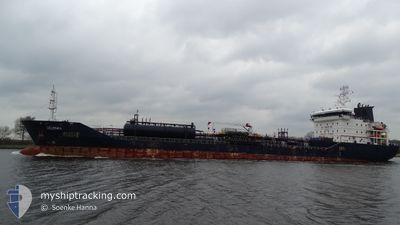
SELENKA
Oil/Chemical Tanker
Current Trip
CI ABC
| Time Travelled | 1 day |
|---|---|
| Remaining Time | --- |
| Distance Travelled | 420.92 nm |
| Remaining Distance | --- |
| AVG Speed | 14.7 Knots |
| MAX Speed | 15.4 Knots |
| AVG Wind | 11.5 knots |
| MAX Wind | 17 knots |
| MIN Temp | 19.5°C / 67.1°F |
| MAX Temp | 21.9°C / 71.42°F |
| Draught | 6.2 m |
| Position Received | 15 m ago |
Current Position
| Longitude | -18.09887° |
|---|---|
| Latitude | 21.77068° |
| Status | Under way using engine |
| Speed | 14.7 Knots |
| Course | 204.2° |
| Area | North Atlantic Ocean |
| Station | T-AIS |
| Position Received | 15 m ago |
Info
Information
The current position of SELENKA is in North Atlantic Ocean with coordinates 21.77068° / -18.09887° as reported on 2024-04-19 21:28 by AIS to our vessel tracker app. The vessel's current speed is 14.7 Knots
The vessel SELENKA (IMO: 9447067, MMSI: 249598000) is a Oil/Chemical Tanker that was built in 2009 ( 15 years old ). It's sailing under the flag of [MT] Malta.
In this page you can find informations about the vessels current position, last detected port calls, and current voyage information. If the vessels is not in coverage by AIS you will find the latest position.
The current position of SELENKA is detected by our AIS receivers and we are not responsible for the reliability of the data. The last position was recorded while the vessel was in Coverage by the Ais receivers of our vessel tracking app.
The current draught of SELENKA as reported by AIS is 6.2 meters
Weather
| Temperature | 20.3°C / 68.54°F |
|---|---|
| Wind Speed | 17 knots |
| Direction | 9° N |
| Pressure | 1015.5 hPa |
| Humidity | 87.9 % |
| Cloud Coverage | 91 % |
Featured Company
Last Port Calls
| Port | Arrival | Departure | Time In Port |
|---|---|---|---|
| 2024-04-18 05:58 | 2024-04-18 16:52 | 10 h | |
| 2024-04-13 02:18 | 2024-04-16 12:32 | 3 d | |
| 2024-03-27 21:49 | 2024-03-31 06:46 | 3 d | |
| 2024-02-15 12:01 | 2024-03-18 14:57 | ||
| 2024-02-07 06:46 | 2024-02-08 07:18 | 1 d |
Most Visited Ports (Last year)
| Port | Arrivals | |
|---|---|---|
| 6 | ||
| 5 | ||
| 3 | ||
| 2 | ||
| 2 | ||
| 2 |
Last Trips
| Origin | Departure | Destination | Arrival | Distance | |
|---|---|---|---|---|---|
| 2024-04-16 13:32 | 2024-04-18 06:58 | 557.82 nm | |||
| 2024-03-31 08:46 | 2024-04-13 02:18 | 2120.27 nm | |||
| 2024-03-18 17:57 | 2024-03-27 23:49 | 833.43 nm | |||
| 2024-02-08 10:18 | 2024-02-15 15:01 | 939.18 nm | |||
| 2024-01-25 04:25 | 2024-02-07 09:46 | 3493.51 nm |
Events
| Time | Event | Details | Position / Dest | Info |
|---|---|---|---|---|
| 2024-04-19 21:31 | Status Changed | Default Under way using engine |
21.75938 / -18.10427
CI ABC
|
Speed: 14.7 kn Course: 204.2° |
| 2024-04-19 20:57 | Status Changed | Under way using engine Default |
21.88538 / -18.04272
CI ABC
|
Speed: 14.6 kn Course: 208° |
| 2024-04-19 20:53 | Status Changed | Default Under way using engine |
21.90133 / -18.03350
CI ABC
|
Speed: 14.7 kn Course: 208.7° |
| 2024-04-19 20:32 | Status Changed | Under way using engine Default |
21.97467 / -17.99000
CI ABC
|
Speed: 14.4 kn Course: 209° |
| 2024-04-19 20:29 | Status Changed | Default Under way using engine |
21.98733 / -17.98233
CI ABC
|
Speed: 14.4 kn Course: 208° |
| 2024-04-19 20:15 | Status Changed | Under way using engine Default |
22.03603 / -17.95367
CI ABC
|
Speed: 14.3 kn Course: 208° |
| 2024-04-19 20:11 | Status Changed | Default Under way using engine |
22.04974 / -17.94580
CI ABC
|
Speed: 14.4 kn Course: 208.3° |
| 2024-04-19 19:19 | Status Changed | Under way using engine Default |
22.23150 / -17.83950
CI ABC
|
Speed: 14 kn Course: 201° |
| 2024-04-19 19:16 | Status Changed | Default Under way using engine |
22.24367 / -17.83450
CI ABC
|
Speed: 13.9 kn Course: 201° |
| 2024-04-19 18:41 | Status Changed | Under way using engine Default |
22.37060 / -17.78307
CI ABC
|
Speed: 13.9 kn Course: 202° |