
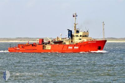
SEAMAR SPLENDID
Research/Survey Vessel
Current Trip
| Trip Time | 1 day |
|---|---|
| Trip Distance | 111.11 nm |
| AVG Speed | 10.9 Knots |
| MAX Speed | 14.5 Knots |
| Draught | 3.5 m |
| AVG Wind | 14.6 knots |
| MAX Wind | 15.9 knots |
| MIN Temp | 6°C / 42.8°F |
| MAX Temp | 8.4°C / 47.12°F |
| Position Received | 3 m ago |
Current Position
| Longitude | 4.77469° |
|---|---|
| Latitude | 52.96039° |
| Status | Moored |
| Speed | |
| Course | 298° |
| Area | North Sea |
| Station | T-AIS |
| Position Received | 3 m ago |
Info
Information
The current position of SEAMAR SPLENDID is in North Sea with coordinates 52.96039° / 4.77469° as reported on 2024-04-19 06:09 by AIS to our vessel tracker app. The vessel's current speed is 0 Knots and is currently inside the port of DEN HELDER.
The vessel SEAMAR SPLENDID (IMO: 8503515, MMSI: 236519000) is a Research/Survey Vessel that was built in 1986 ( 38 years old ). It's sailing under the flag of [GI] Gibraltar.
In this page you can find informations about the vessels current position, last detected port calls, and current voyage information. If the vessels is not in coverage by AIS you will find the latest position.
The current position of SEAMAR SPLENDID is detected by our AIS receivers and we are not responsible for the reliability of the data. The last position was recorded while the vessel was in Coverage by the Ais receivers of our vessel tracking app.
The current draught of SEAMAR SPLENDID as reported by AIS is 3.5 meters
Weather
| Temperature | 9.6°C / 49.28°F |
|---|---|
| Wind Speed | 21 knots |
| Direction | 310° NW |
| Pressure | 1006.8 hPa |
| Humidity | 84.3 % |
| Cloud Coverage | 100 % |
Featured Company
Last Port Calls
| Port | Arrival | Departure | Time In Port |
|---|---|---|---|
| 2024-04-18 16:25 | |||
| 2024-04-13 17:20 | 2024-04-17 04:03 | 3 d | |
| 2024-04-08 21:10 | 2024-04-12 21:47 | 4 d | |
| 2024-04-01 17:23 | 2024-04-07 21:48 | 6 d | |
| 2024-03-22 09:09 | 2024-03-29 21:51 | 7 d | |
| 2024-03-13 16:10 | 2024-03-17 22:57 | 4 d | |
| 2024-03-09 19:22 | 2024-03-11 22:56 | 2 d | |
| 2024-03-03 23:03 | 2024-03-07 11:20 | 3 d | |
| 2024-03-03 18:41 | 2024-03-03 19:03 | 22 m | |
| 2024-02-03 12:10 | 2024-03-03 17:17 | 29 d |
Most Visited Ports (Last year)
| Port | Arrivals | |
|---|---|---|
| 40 | ||
| 2 | ||
| 1 |
Last Trips
| Origin | Departure | Destination | Arrival | Distance | |
|---|---|---|---|---|---|
| 2024-04-17 06:03 | 2024-04-18 18:25 | 111.11 nm | |||
| 2024-04-12 23:47 | 2024-04-13 19:20 | 99.76 nm | |||
| 2024-04-07 23:48 | 2024-04-08 23:10 | 100.51 nm | |||
| 2024-03-29 22:51 | 2024-04-01 19:23 | 118.19 nm | |||
| 2024-03-17 23:57 | 2024-03-22 10:09 | 124.12 nm | |||
| 2024-03-11 23:56 | 2024-03-13 17:10 | 80.92 nm | |||
| 2024-03-07 12:20 | 2024-03-09 20:22 | 93.19 nm | |||
| 2024-03-03 20:03 | 2024-03-04 00:03 | 34.92 nm | |||
| 2024-03-03 18:17 | 2024-03-03 19:41 | 10.64 nm | |||
| 2024-02-03 12:06 | 2024-02-03 13:10 | 9.04 nm |
Events
| Time | Event | Details | Position / Dest | Info |
|---|---|---|---|---|
| 2024-04-18 16:38 | Status Changed | Moored Under way using engine |
52.96038 / 4.77472
[NL] DEN HELDER
|
Speed: Course: 298° |
| 2024-04-18 16:34 | STOP Moving |
52.96037 / 4.77475
[NL] DEN HELDER
|
Speed: 0.2 kn Course: 287° |
|
| 2024-04-18 16:25 | PORT ARRIVAL |
|
52.96512 / 4.78690
[NL] DEN HELDER
|
Speed: 11 kn Course: 174.6° |
| 2024-04-18 15:07 | Destination Changed | DEN HELDER L10-E |
52.96097 / 4.46221
DEN HELDER
|
Speed: 12 kn Course: 129.7° |
| 2024-04-18 15:07 | ETA Changed | 2024/04/18 16:45 2024/04/17 08:30 |
52.96097 / 4.46221
DEN HELDER
|
Speed: 12 kn Course: 129.7° |
| 2024-04-18 14:19 | IN Coverage |
53.07329 / 4.28658
North Sea
|
Speed: 11.7 kn Course: 158.1° |
|
| 2024-04-17 14:33 | STOP Moving |
53.42520 / 4.27873
L10-E
|
Speed: 0.3 kn Course: 309° |
|
| 2024-04-17 05:53 | Status Changed | Default Under way using engine |
53.02464 / 4.31876
L10-E
|
Speed: 11.3 kn Course: 314.2° |
| 2024-04-17 05:50 | OUT of Coverage |
53.01806 / 4.32835
North Sea
L10-E
|
Speed: 11.3 kn Course: 314.2° |
|
| 2024-04-17 05:49 | Status Changed | Under way using engine Default |
53.01590 / 4.33188
L10-E
|
Speed: 11.3 kn Course: 307° |