
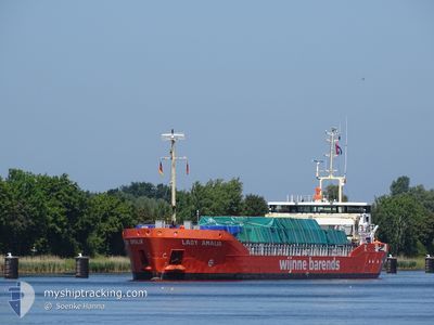
LADY AMALIA
General Cargo
Current Trip
| Time Travelled | 12 days |
|---|---|
| Remaining Time | --- |
| Distance Travelled | 2737.51 nm |
| Remaining Distance | --- |
| AVG Speed | 7.9 Knots |
| MAX Speed | 11.8 Knots |
| AVG Wind | 11.6 knots |
| MAX Wind | 29 knots |
| MIN Temp | 0.6°C / 33.08°F |
| MAX Temp | 20.5°C / 68.9°F |
| Draught | 5 m |
| Position Received | Now |
Current Position
| Longitude | 11.81611° |
|---|---|
| Latitude | 54.41058° |
| Status | Under way using engine |
| Speed | 9.5 Knots |
| Course | 91.3° |
| Area | Baltic Sea |
| Station | T-AIS |
| Position Received | Now |
Info
Information
The current position of LADY AMALIA is in Baltic Sea with coordinates 54.41058° / 11.81611° as reported on 2024-04-25 13:36 by AIS to our vessel tracker app. The vessel's current speed is 9.5 Knots and is heading at the port of VASTERAS. The estimated time of arrival as calculated by MyShipTracking vessel tracking app is 2024-04-27 06:00 LT
The vessel LADY AMALIA (IMO: 9624847, MMSI: 246685000) is a General Cargo that was built in 2012 ( 12 years old ). It's sailing under the flag of [NL] Netherlands.
In this page you can find informations about the vessels current position, last detected port calls, and current voyage information. If the vessels is not in coverage by AIS you will find the latest position.
The current position of LADY AMALIA is detected by our AIS receivers and we are not responsible for the reliability of the data. The last position was recorded while the vessel was in Coverage by the Ais receivers of our vessel tracking app.
The current draught of LADY AMALIA as reported by AIS is 5 meters
Weather
| Temperature | 7.8°C / 46.04°F |
|---|---|
| Wind Speed | 11 knots |
| Direction | 88° E |
| Pressure | 1002.9 hPa |
| Humidity | 70.9 % |
| Cloud Coverage | 100 % |
Featured Company
Last Port Calls
| Port | Arrival | Departure | Time In Port |
|---|---|---|---|
| 2024-04-10 17:46 | 2024-04-12 14:54 | 1 d | |
| 2024-04-07 09:30 | 2024-04-07 19:16 | 9 h | |
| 2024-03-25 11:21 | 2024-03-28 20:36 | 3 d | |
| 2024-03-25 09:59 | 2024-03-25 10:28 | 29 m | |
| 2024-03-21 05:14 | |||
| 2024-03-18 13:56 | 2024-03-19 17:20 | 1 d | |
| 2024-03-14 20:09 | 2024-03-15 20:14 | 1 d | |
| 2024-03-14 19:20 | 2024-03-14 19:59 | 39 m | |
| 2024-03-13 06:38 | 2024-03-14 18:21 | 1 d | |
| 2024-03-03 14:01 | 2024-03-06 10:36 | 2 d |
Last Trips
| Origin | Departure | Destination | Arrival | Distance | |
|---|---|---|---|---|---|
| 2024-04-07 21:16 | 2024-04-10 19:46 | 717.89 nm | |||
| 2024-03-28 21:36 | 2024-04-07 11:30 | 1877.44 nm | |||
| 2024-03-25 11:28 | 2024-03-25 12:21 | 7.06 nm | |||
| 2024-03-25 11:28 | 2024-03-25 10:59 | 7.06 nm | |||
| 2024-03-19 18:20 | 2024-03-21 07:14 | 315.08 nm | |||
| 2024-03-15 21:14 | 2024-03-18 14:56 | 548.67 nm | |||
| 2024-03-14 20:59 | 2024-03-14 21:09 | 0.41 nm | |||
| 2024-03-14 19:21 | 2024-03-14 20:20 | 9.26 nm | |||
| 2024-03-06 10:36 | 2024-03-13 07:38 | 1118.73 nm | |||
| 2024-03-01 13:25 | 2024-03-03 14:01 | 202.37 nm |
Events
| Time | Event | Details | Position / Dest | Info |
|---|---|---|---|---|
| 2024-04-25 12:02 | Detected in Sea | Danish part of the Baltic Sea |
54.50404 / 11.43771
Baltic Sea
SEVST
|
Speed: 9.2 kn Course: 117.9° |
| 2024-04-25 09:26 | Detected in Sea | German part of the Baltic Sea |
54.57050 / 10.78464
Baltic Sea
SEVST
|
Speed: 9.8 kn Course: 83.1° |
| 2024-04-25 08:47 | Change Sea Area | Danish part of the Baltic Sea German part of the Baltic Sea |
54.55811 / 10.60455
Baltic Sea
SEVST
|
Speed: 9.5 kn Course: 83° |
| 2024-04-25 08:07 | Draught Changed | 5 5.1 |
54.52069 / 10.43181
SEVST
|
Speed: 9.5 kn Course: 68.5° |
| 2024-04-25 07:23 | Change Sea Area | German part of the Baltic Sea German part of the North Sea |
54.46346 / 10.26870
Baltic Sea
SEVST
|
Speed: 9.3 kn Course: 34.3° |
| 2024-04-25 06:28 | START Moving | 1.31 nm, South West of STICKENHΟRN SPORT |
54.36568 / 10.14505
SEVST
|
Speed: 3.1 kn Course: 98° |
| 2024-04-25 05:53 | STOP Moving | 1.37 nm, South West of STICKENHΟRN SPORT |
54.36614 / 10.14139
SEVST
|
Speed: 0.2 kn Course: 105° |
| 2024-04-25 00:25 | Status Changed | Under way using engine Default |
54.12156 / 9.32861
SEVST
|
Speed: 6.6 kn Course: 357° |
| 2024-04-25 00:19 | Status Changed | Default Under way using engine |
54.11081 / 9.32921
SEVST
|
Speed: 6.7 kn Course: 17.7° |
| 2024-04-24 23:42 | Status Changed | Under way using engine Default |
54.04490 / 9.30559
SEVST
|
Speed: Course: 6° |