
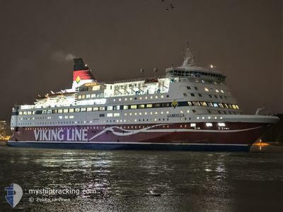
GABRIELLA
Ro-Ro/Passenger Ship
Current Trip
| Time Travelled | 5 h, 36 mins |
|---|---|
| Remaining Time | 23 mins |
| Distance Travelled | 73.56 nm |
| Remaining Distance | 5.67 nm |
| AVG Speed | 12.8 Knots |
| MAX Speed | 17.2 Knots |
| AVG Wind | 7.7 knots |
| MAX Wind | 14 knots |
| MIN Temp | 0.7°C / 33.26°F |
| MAX Temp | 5.7°C / 42.26°F |
| Draught | 6.3 m |
| Position Received | 1 m ago |
Current Position
| Longitude | 18.27817° |
|---|---|
| Latitude | 59.37150° |
| Status | Under way using engine |
| Speed | 12 Knots |
| Course | 227.8° |
| Area | Baltic Sea |
| Station | T-AIS |
| Position Received | 1 m ago |
Info
Information
The current position of GABRIELLA is in Baltic Sea with coordinates 59.37150° / 18.27817° as reported on 2024-04-24 07:11 by AIS to our vessel tracker app. The vessel's current speed is 12 Knots and is heading at the port of STOCKHOLM. The estimated time of arrival as calculated by MyShipTracking vessel tracking app is 2024-04-24 07:35 LT
The vessel GABRIELLA (IMO: 8917601, MMSI: 230361000) is a Ro-Ro/Passenger Ship that was built in 1992 ( 32 years old ). It's sailing under the flag of [FI] Finland.
In this page you can find informations about the vessels current position, last detected port calls, and current voyage information. If the vessels is not in coverage by AIS you will find the latest position.
The current position of GABRIELLA is detected by our AIS receivers and we are not responsible for the reliability of the data. The last position was recorded while the vessel was in Coverage by the Ais receivers of our vessel tracking app.
The current draught of GABRIELLA as reported by AIS is 6.3 meters
Weather
| Temperature | 5.1°C / 41.18°F |
|---|---|
| Wind Speed | 6 knots |
| Direction | 174° S |
| Pressure | 1010.4 hPa |
| Humidity | 66 % |
| Cloud Coverage | 66 % |
Featured Company
Last Port Calls
| Port | Arrival | Departure | Time In Port |
|---|---|---|---|
| 2024-04-24 01:14 | 2024-04-24 01:36 | 22 m | |
| 2024-04-23 07:02 | 2024-04-23 14:19 | 7 h | |
| 2024-04-22 20:25 | 2024-04-22 20:48 | 23 m | |
| 2024-04-22 07:33 | 2024-04-22 14:37 | 7 h | |
| 2024-04-22 01:16 | 2024-04-22 01:38 | 22 m | |
| 2024-04-21 07:03 | 2024-04-21 14:16 | 7 h | |
| 2024-04-20 20:24 | 2024-04-20 20:43 | 19 m | |
| 2024-04-20 07:33 | 2024-04-20 14:36 | 7 h | |
| 2024-04-20 01:13 | 2024-04-20 01:35 | 22 m | |
| 2024-04-19 07:05 | 2024-04-19 14:23 | 7 h |
Most Visited Ports (Last year)
| Port | Arrivals | |
|---|---|---|
| 249 | ||
| 202 | ||
| 176 | ||
| 23 | ||
| 4 |
Last Trips
| Origin | Departure | Destination | Arrival | Distance | |
|---|---|---|---|---|---|
| 2024-04-23 17:19 | 2024-04-24 04:14 | 183.77 nm | |||
| 2024-04-22 23:48 | 2024-04-23 10:02 | 185.01 nm | |||
| 2024-04-22 16:37 | 2024-04-22 23:25 | 78.36 nm | |||
| 2024-04-22 04:38 | 2024-04-22 09:33 | 78.54 nm | |||
| 2024-04-21 17:16 | 2024-04-22 04:16 | 183.98 nm | |||
| 2024-04-20 23:43 | 2024-04-21 10:03 | 184.91 nm | |||
| 2024-04-20 16:36 | 2024-04-20 23:24 | 78.05 nm | |||
| 2024-04-20 04:35 | 2024-04-20 09:33 | 78.58 nm | |||
| 2024-04-19 17:23 | 2024-04-20 04:13 | 183.68 nm | |||
| 2024-04-18 23:44 | 2024-04-19 10:05 | 184.84 nm |
Events
| Time | Event | Details | Position / Dest | Info |
|---|---|---|---|---|
| 2024-04-24 02:55 | Change Sea Area | Swedish part of the Baltic Sea Swedish part of the Gulf of Bothnia |
59.82450 / 19.47817
Baltic Sea
FIHEL<>FIMHQ<>SESTO
|
Speed: 17 kn Course: 223.6° |
| 2024-04-24 02:47 | Change Sea Area | Swedish part of the Gulf of Bothnia Finnish part of the Gulf of Bothnia |
59.85493 / 19.53625
Gulf of Bothnia
FIHEL<>FIMHQ<>SESTO
|
Speed: 17 kn Course: 224.5° |
| 2024-04-24 01:36 | PORT DEPARTURE |
|
60.08600 / 19.92733
FIHEL<>FIMHQ<>SESTO
|
Speed: 6.4 kn Course: 175° |
| 2024-04-24 01:33 | START Moving |
60.09033 / 19.92717
[FI] MARIEHAMN
|
Speed: 3.2 kn Course: 186° |
|
| 2024-04-24 01:18 | STOP Moving |
60.08831 / 19.92766
[FI] MARIEHAMN
|
Speed: 0.1 kn Course: 171° |
|
| 2024-04-24 01:14 | PORT ARRIVAL |
|
60.08738 / 19.92842
[FI] MARIEHAMN
|
Speed: 7.2 kn Course: 0° |
| 2024-04-23 23:31 | Change Sea Area | Finnish part of the Gulf of Bothnia Finnish part of the Baltic Sea |
59.75283 / 20.38117
Gulf of Bothnia
FIHEL<>FIMHQ<>SESTO
|
Speed: 16.4 kn Course: 300.2° |
| 2024-04-23 23:29 | Status Changed | Under way using engine Default |
59.74787 / 20.39828
FIHEL<>FIMHQ<>SESTO
|
Speed: 16.6 kn Course: 301° |
| 2024-04-23 23:28 | Status Changed | Default Under way using engine |
59.74548 / 20.40607
FIHEL<>FIMHQ<>SESTO
|
Speed: 16.9 kn Course: 299.3° |
| 2024-04-23 23:07 | Status Changed | Under way using engine Default |
59.68767 / 20.56417
FIHEL<>FIMHQ<>SESTO
|
Speed: 16.7 kn Course: 289° |