
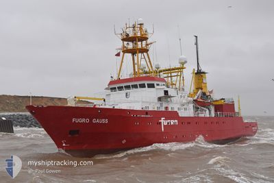
FUGRO GAUSS
Research/Survey Vessel
Current Trip
SURVEY AREA
| Time Travelled | 7 days |
|---|---|
| Remaining Time | --- |
| Distance Travelled | 1189.77 nm |
| Remaining Distance | --- |
| AVG Speed | 7.3 Knots |
| MAX Speed | 9.7 Knots |
| AVG Wind | 10.3 knots |
| MAX Wind | 17 knots |
| MIN Temp | 24.8°C / 76.64°F |
| MAX Temp | 27.7°C / 81.86°F |
| Draught | 5 m |
| Position Received | 4 h, 7 m ago |
Current Position
| Longitude | -72.68671° |
|---|---|
| Latitude | 21.56606° |
| Status | Restricted manoeuverability |
| Speed | 6.5 Knots |
| Course | 186.7° |
| Area | North Atlantic Ocean |
| Station | T-AIS |
| Position Received | 4 h, 7 m ago |
Info
Information
The current position of FUGRO GAUSS is in North Atlantic Ocean with coordinates 21.56606° / -72.68671° as reported on 2024-04-24 20:44 by AIS to our vessel tracker app. The vessel's current speed is 6.5 Knots
The vessel FUGRO GAUSS (IMO: 7824883, MMSI: 236403000) is a Research/Survey Vessel that was built in 1980 ( 44 years old ). It's sailing under the flag of [GI] Gibraltar.
In this page you can find informations about the vessels current position, last detected port calls, and current voyage information. If the vessels is not in coverage by AIS you will find the latest position.
The current position of FUGRO GAUSS is detected by our AIS receivers and we are not responsible for the reliability of the data. The last position was recorded while the vessel was in Coverage by the Ais receivers of our vessel tracking app.
The current draught of FUGRO GAUSS as reported by AIS is 5 meters
Weather
| Temperature | 25.6°C / 78.08°F |
|---|---|
| Wind Speed | 13 knots |
| Direction | 65° ENE |
| Pressure | 1016.6 hPa |
| Humidity | 72.5 % |
| Cloud Coverage | 4 % |
Featured Company
Last Port Calls
| Port | Arrival | Departure | Time In Port |
|---|---|---|---|
| 2024-04-16 13:03 | 2024-04-17 23:19 | 1 d | |
| 2024-03-26 14:34 | 2024-04-06 18:58 | 11 d | |
| 2024-03-18 15:19 | 2024-03-19 00:22 | 9 h | |
| 2024-02-26 13:20 | 2024-03-01 19:40 | 4 d | |
| 2024-02-16 23:50 | 2024-02-19 19:23 | 2 d | |
| 2024-02-16 23:37 | 2024-02-16 23:46 | 8 m |
Most Visited Ports (Last year)
| Port | Arrivals | |
|---|---|---|
| 5 | ||
| 5 | ||
| 3 | ||
| 2 | ||
| 2 | ||
| 2 |
Last Trips
| Origin | Departure | Destination | Arrival | Distance | |
|---|---|---|---|---|---|
| 2024-04-06 13:58 | 2024-04-16 08:03 | 915.45 nm | |||
| 2024-03-18 18:22 | 2024-03-26 09:34 | 804.51 nm | |||
| 2024-03-01 14:40 | 2024-03-18 09:19 | 958.89 nm | |||
| 2024-02-19 14:23 | 2024-02-26 08:20 | 676.08 nm | |||
| 2024-02-16 18:46 | 2024-02-16 18:50 | 0.23 nm | |||
| 2024-01-25 16:32 | 2024-02-16 18:37 | 2657.23 nm |
Events
| Time | Event | Details | Position / Dest | Info |
|---|---|---|---|---|
| 2024-04-24 20:57 | Status Changed | Default Restricted manoeuverability |
21.54333 / -72.69833
SURVEY AREA
|
Speed: 6.5 kn Course: 186.7° |
| 2024-04-24 20:44 | Change Sea Area | Turks and Caicos part of the North Atlantic Ocean Bahamas part of the North Atlantic Ocean |
21.56606 / -72.68671
North Atlantic Ocean
|
Speed: 6.5 kn Course: 186.7° |
| 2024-04-24 20:44 | Status Changed | Restricted manoeuverability Default |
21.56606 / -72.68671
SURVEY AREA
|
Speed: 6 kn Course: 179° |
| 2024-04-24 20:44 | OUT of Coverage |
21.56606 / -72.68671
North Atlantic Ocean
|
Speed: 6.5 kn Course: 186.7° |
|
| 2024-04-24 20:39 | IN Coverage |
21.56606 / -72.68671
North Atlantic Ocean
|
Speed: 6.5 kn Course: 186.7° |
|
| 2024-04-24 06:00 | Status Changed | Default Under way using engine |
21.12333 / -72.94833
SURVEY AREA
|
Speed: 8.2 kn Course: 18.3° |
| 2024-04-24 05:55 | Status Changed | Under way using engine Default |
21.11563 / -72.95171
SURVEY AREA
|
Speed: 8 kn Course: 18° |
| 2024-04-24 05:55 | OUT of Coverage |
21.11563 / -72.95171
North Atlantic Ocean
|
Speed: 8.2 kn Course: 18.3° |
|
| 2024-04-24 05:48 | Status Changed | Default Under way using engine |
21.09833 / -72.95667
SURVEY AREA
|
Speed: 8.3 kn Course: 18.9° |
| 2024-04-24 05:36 | Status Changed | Under way using engine Default |
21.07151 / -72.96771
SURVEY AREA
|
Speed: 8 kn Course: 20° |