
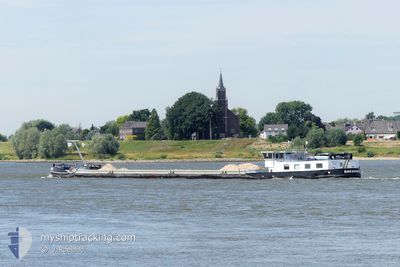
BAKERMAT
Cargo
Current Trip
NTB
| Time Travelled | 8 h, 3 mins |
|---|---|
| Remaining Time | --- |
| Distance Travelled | 37.06 nm |
| Remaining Distance | --- |
| AVG Speed | 6.8 Knots |
| MAX Speed | 8.4 Knots |
| AVG Wind | 20.4 knots |
| MAX Wind | 25.9 knots |
| MIN Temp | 5.6°C / 42.08°F |
| MAX Temp | 8.3°C / 46.94°F |
| Draught | 0.4 m |
| Position Received | 1 m ago |
Current Position
| Longitude | 5.43967° |
|---|---|
| Latitude | 52.71317° |
| Status | Under way using engine |
| Speed | |
| Course | --- |
| Area | North Sea |
| Station | T-AIS |
| Position Received | 1 m ago |
Info
Information
The current position of BAKERMAT is in North Sea with coordinates 52.71317° / 5.43967° as reported on 2024-04-24 12:33 by AIS to our vessel tracker app. The vessel's current speed is 0 Knots
The vessel BAKERMAT (MMSI: 244780678) is a Cargo It's sailing under the flag of [NL] Netherlands.
In this page you can find informations about the vessels current position, last detected port calls, and current voyage information. If the vessels is not in coverage by AIS you will find the latest position.
The current position of BAKERMAT is detected by our AIS receivers and we are not responsible for the reliability of the data. The last position was recorded while the vessel was in Coverage by the Ais receivers of our vessel tracking app.
The current draught of BAKERMAT as reported by AIS is 0.4 meters
Weather
| Temperature | 8°C / 46.4°F |
|---|---|
| Wind Speed | 22 knots |
| Direction | 335° NNW |
| Pressure | 1007.4 hPa |
| Humidity | 68.8 % |
| Cloud Coverage | 99 % |
Featured Company
Last Port Calls
| Port | Arrival | Departure | Time In Port |
|---|---|---|---|
| 2024-04-23 19:00 | 2024-04-24 04:31 | 9 h | |
| 2024-04-23 07:40 | 2024-04-23 11:46 | 4 h | |
| 2024-04-22 07:03 | 2024-04-22 11:29 | 4 h | |
| 2024-04-16 10:03 | 2024-04-16 13:51 | 3 h | |
| 2024-04-15 19:33 | 2024-04-16 04:33 | 8 h | |
| 2024-04-12 13:00 | 2024-04-15 03:40 | 2 d | |
| 2024-04-09 09:03 | 2024-04-09 13:58 | 4 h | |
| 2024-04-05 14:16 | 2024-04-08 04:42 | 2 d | |
| 2024-04-02 14:56 | 2024-04-03 10:12 | 19 h | |
| 2024-04-02 05:08 | 2024-04-02 10:54 | 5 h |
Most Visited Ports (Last year)
| Port | Arrivals | |
|---|---|---|
| 52 | ||
| 30 | ||
| 10 | ||
| 10 | ||
| 9 | ||
| 6 |
Last Trips
| Origin | Departure | Destination | Arrival | Distance | |
|---|---|---|---|---|---|
| 2024-04-23 13:46 | 2024-04-23 21:00 | 38.60 nm | |||
| 2024-04-22 13:29 | 2024-04-23 09:40 | 61.15 nm | |||
| 2024-04-16 15:51 | 2024-04-22 09:03 | 207.96 nm | |||
| 2024-04-16 06:33 | 2024-04-16 12:03 | 28.95 nm | |||
| 2024-04-15 05:40 | 2024-04-15 21:33 | 59.14 nm | |||
| 2024-04-09 15:58 | 2024-04-12 15:00 | 165.83 nm | |||
| 2024-04-08 06:42 | 2024-04-09 11:03 | 98.10 nm | |||
| 2024-04-03 12:12 | 2024-04-05 16:16 | 85.98 nm | |||
| 2024-04-02 12:54 | 2024-04-02 16:56 | 20.91 nm | |||
| 2024-03-21 16:34 | 2024-04-02 07:08 | 139.41 nm |
Events
| Time | Event | Details | Position / Dest | Info |
|---|---|---|---|---|
| 2024-04-24 11:33 | STOP Moving | 5.3 nm, East of ENKHUIZEN |
52.71299 / 5.43944
NTB
|
Speed: 0.2 kn Course: 511° |
| 2024-04-24 10:44 | START Moving | 0.47 nm, South of ENKHUIZEN |
52.69264 / 5.29599
NTB
|
Speed: 6.5 kn Course: 3.6° |
| 2024-04-24 10:39 | STOP Moving | 0.6 nm, South of ENKHUIZEN |
52.69053 / 5.29547
NTB
|
Speed: 0.1 kn Course: 511° |
| 2024-04-24 10:14 | START Moving | 1.55 nm, South of BOVENKARSPEL |
52.66221 / 5.24875
NTB
|
Speed: 8.2 kn Course: 29.9° |
| 2024-04-24 10:14 | STOP Moving | 1.67 nm, South West of BOVENKARSPEL |
52.66054 / 5.24728
NTB
|
Speed: Course: 0° |
| 2024-04-24 09:06 | START Moving | 3.31 nm, East of EDAM |
52.53227 / 5.13706
NTB
|
Speed: 8.1 kn Course: 31.5° |
| 2024-04-24 09:05 | STOP Moving | 3.23 nm, East of EDAM |
52.53067 / 5.13546
NTB
|
Speed: Course: 0° |
| 2024-04-24 08:33 | START Moving | 1 nm, North West of MARKEN |
52.47189 / 5.08522
NTB
|
Speed: 6.2 kn Course: 3.1° |
| 2024-04-24 06:55 | STOP Moving | 0.91 nm, North West of MARKEN |
52.46988 / 5.08483
NTB
|
Speed: 0.2 kn Course: 511° |
| 2024-04-24 04:31 | PORT DEPARTURE |
|
52.68200 / 5.27198
NTB
|
Speed: 3.9 kn Course: 218.2° |