
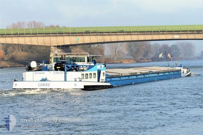
CORSO
Other Type
Current Trip
| Time Travelled | 1 day |
|---|---|
| Remaining Time | 2 h, 19 mins |
| Distance Travelled | 104.95 nm |
| Remaining Distance | 14.86 nm |
| AVG Speed | 5.5 Knots |
| MAX Speed | 6.9 Knots |
| AVG Wind | 7.9 knots |
| MAX Wind | 10 knots |
| MIN Temp | 1.7°C / 35.06°F |
| MAX Temp | 11.6°C / 52.88°F |
| Draught | 0 m |
| Position Received | 1 m ago |
Current Position
| Longitude | 5.82371° |
|---|---|
| Latitude | 51.07744° |
| Status | Aground |
| Speed | 5.8 Knots |
| Course | 208.6° |
| Area | North Sea |
| Station | T-AIS |
| Position Received | 1 m ago |
Info
Information
The current position of CORSO is in North Sea with coordinates 51.07744° / 5.82371° as reported on 2024-04-18 12:44 by AIS to our vessel tracker app. The vessel's current speed is 5.8 Knots and is heading at the port of MAASTRICHT. The estimated time of arrival as calculated by MyShipTracking vessel tracking app is 2024-04-18 15:04 LT
The vessel CORSO (MMSI: 244710433) is a Other Type It's sailing under the flag of [NL] Netherlands.
In this page you can find informations about the vessels current position, last detected port calls, and current voyage information. If the vessels is not in coverage by AIS you will find the latest position.
The current position of CORSO is detected by our AIS receivers and we are not responsible for the reliability of the data. The last position was recorded while the vessel was in Coverage by the Ais receivers of our vessel tracking app.
Weather
| Temperature | 10.9°C / 51.62°F |
|---|---|
| Wind Speed | 7 knots |
| Direction | 320° NW |
| Pressure | 1020.3 hPa |
| Humidity | 47.7 % |
| Cloud Coverage | 45 % |
Featured Company
Last Port Calls
| Port | Arrival | Departure | Time In Port |
|---|---|---|---|
| 2024-04-12 13:55 | 2024-04-17 03:35 | 4 d | |
| 2024-04-12 13:20 | 2024-04-12 13:38 | 18 m | |
| 2024-04-12 08:43 | 2024-04-12 12:33 | 3 h | |
| 2024-04-11 19:32 | 2024-04-12 04:01 | 8 h | |
| 2024-04-10 19:01 | 2024-04-11 07:58 | 12 h | |
| 2024-04-10 13:41 | 2024-04-10 14:12 | 31 m | |
| 2024-04-05 08:22 | 2024-04-10 09:00 | 5 d | |
| 2024-04-04 20:38 | 2024-04-05 03:32 | 6 h | |
| 2024-04-04 06:51 | 2024-04-04 15:01 | 8 h | |
| 2024-04-03 18:42 | 2024-04-04 05:48 | 11 h |
Most Visited Ports (Last year)
| Port | Arrivals | |
|---|---|---|
| 38 | ||
| 28 | ||
| 17 | ||
| 12 | ||
| 8 | ||
| 8 |
Last Trips
| Origin | Departure | Destination | Arrival | Distance | |
|---|---|---|---|---|---|
| 2024-04-12 15:38 | 2024-04-12 15:55 | 1.44 nm | |||
| 2024-04-12 14:33 | 2024-04-12 15:20 | 6.49 nm | |||
| 2024-04-12 06:01 | 2024-04-12 10:43 | 34.83 nm | |||
| 2024-04-11 09:58 | 2024-04-11 21:32 | 41.05 nm | |||
| 2024-04-10 16:12 | 2024-04-10 21:01 | 36.01 nm | |||
| 2024-04-10 11:00 | 2024-04-10 15:41 | 34.30 nm | |||
| 2024-04-05 05:32 | 2024-04-05 10:22 | 34.66 nm | |||
| 2024-04-04 17:01 | 2024-04-04 22:38 | 37.75 nm | |||
| 2024-04-04 07:48 | 2024-04-04 08:51 | 9.35 nm | |||
| 2024-04-03 17:58 | 2024-04-03 20:42 | 22.96 nm |
Events
| Time | Event | Details | Position / Dest | Info |
|---|---|---|---|---|
| 2024-04-18 12:26 | Status Changed | Aground Default |
51.10585 / 5.84838
MAASTRICHT
|
Speed: Course: -1° |
| 2024-04-18 12:26 | START Moving | 0.86 nm, East of OHE EN LAAK |
51.10585 / 5.84838
MAASTRICHT
|
Speed: 6.6 kn Course: 209.3° |
| 2024-04-18 12:01 | Status Changed | Default Aground |
51.14167 / 5.87833
MAASTRICHT
|
Speed: 6.7 kn Course: 237.1° |
| 2024-04-18 12:01 | STOP Moving | 0.41 nm, South West of MAASBRACHT |
51.14167 / 5.87833
MAASTRICHT
|
Speed: Course: -1° |
| 2024-04-18 11:24 | IN Coverage |
51.16800 / 5.91068
North Sea
MAASTRICHT
|
Speed: 6.9 kn Course: 231.9° |
|
| 2024-04-18 10:00 | OUT of Coverage |
51.23862 / 6.00551
North Sea
MAASTRICHT
|
Speed: 5.2 kn Course: 196° |
|
| 2024-04-18 09:59 | IN Coverage |
51.24025 / 6.00610
North Sea
MAASTRICHT
|
Speed: 5.2 kn Course: 191° |
|
| 2024-04-18 06:49 | Status Changed | Default Aground |
51.45167 / 6.16500
MAASTRICHT
|
Speed: 5.6 kn Course: 123.4° |
| 2024-04-18 05:50 | OUT of Coverage |
51.52825 / 6.12582
North Sea
MAASTRICHT
|
Speed: 5.6 kn Course: 123.4° |
|
| 2024-04-18 04:09 | START Moving | 2.15 nm, South East of BOXMEER |
51.63848 / 5.98782
MAASTRICHT
|
Speed: 4.8 kn Course: 124° |