
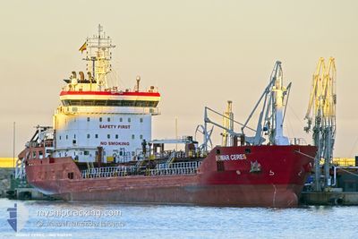
BOMAR CERES
Oil/Chemical Tanker
Current Trip
| Trip Time | 2 days |
|---|---|
| Trip Distance | 537.44 nm |
| AVG Speed | 8.9 Knots |
| MAX Speed | 13.1 Knots |
| Draught | 5.3 m |
| AVG Wind | 9.1 knots |
| MAX Wind | 20.9 knots |
| MIN Temp | 14.8°C / 58.64°F |
| MAX Temp | 21°C / 69.8°F |
| Position Received | 6 m ago |
Current Position
| Longitude | -5.40242° |
|---|---|
| Latitude | 36.17633° |
| Status | Moored |
| Speed | |
| Course | 249° |
| Area | Strait of Gibraltar |
| Station | T-AIS |
| Position Received | 6 m ago |
Info
Information
The current position of BOMAR CERES is in Strait of Gibraltar with coordinates 36.17633° / -5.40242° as reported on 2024-04-25 16:19 by AIS to our vessel tracker app. The vessel's current speed is 0 Knots and is currently inside the port of CARTEYA GUADARRANQUE.
The vessel BOMAR CERES (IMO: 9367231, MMSI: 256815000) is a Oil/Chemical Tanker that was built in 2007 ( 17 years old ). It's sailing under the flag of [MT] Malta.
In this page you can find informations about the vessels current position, last detected port calls, and current voyage information. If the vessels is not in coverage by AIS you will find the latest position.
The current position of BOMAR CERES is detected by our AIS receivers and we are not responsible for the reliability of the data. The last position was recorded while the vessel was in Coverage by the Ais receivers of our vessel tracking app.
The current draught of BOMAR CERES as reported by AIS is 5.3 meters
Weather
| Temperature | 19.8°C / 67.64°F |
|---|---|
| Wind Speed | 12 knots |
| Direction | 273° W |
| Pressure | 1009.5 hPa |
| Humidity | 44.6 % |
| Cloud Coverage | 76 % |
Featured Company
Last Port Calls
| Port | Arrival | Departure | Time In Port |
|---|---|---|---|
| 2024-04-25 10:18 | |||
| 2024-04-21 13:53 | 2024-04-22 15:18 | 1 d | |
| 2024-04-19 06:07 | 2024-04-19 17:41 | 11 h | |
| 2024-04-14 22:46 | 2024-04-16 10:47 | 1 d | |
| 2024-04-10 04:56 | 2024-04-11 09:52 | 1 d | |
| 2024-04-01 15:15 | 2024-04-04 14:38 | 2 d | |
| 2024-03-22 07:59 | 2024-03-23 07:55 | 23 h | |
| 2024-03-15 16:27 | 2024-03-16 21:32 | 1 d | |
| 2024-03-07 12:26 | 2024-03-10 23:30 | 3 d | |
| 2024-03-03 16:09 | 2024-03-04 19:31 | 1 d |
Last Trips
| Origin | Departure | Destination | Arrival | Distance | |
|---|---|---|---|---|---|
| 2024-04-22 16:18 | 2024-04-25 12:18 | 537.44 nm | |||
| 2024-04-19 19:41 | 2024-04-21 14:53 | 464.60 nm | |||
| 2024-04-16 12:47 | 2024-04-19 08:07 | 699.13 nm | |||
| 2024-04-11 10:52 | 2024-04-15 00:46 | 407.91 nm | |||
| 2024-04-04 17:38 | 2024-04-10 05:56 | 1147.38 nm | |||
| 2024-03-23 08:55 | 2024-04-01 18:15 | 1083.48 nm | |||
| 2024-03-16 22:32 | 2024-03-22 08:59 | 1244.86 nm | |||
| 2024-03-10 23:30 | 2024-03-15 17:27 | 871.26 nm | |||
| 2024-03-04 19:31 | 2024-03-07 12:26 | 271.03 nm | |||
| 2024-02-22 09:36 | 2024-03-03 16:09 | 2102.84 nm |
Events
| Time | Event | Details | Position / Dest | Info |
|---|---|---|---|---|
| 2024-04-25 10:22 | STOP Moving |
36.17627 / -5.40247
[ES] CARTEYA GUADARRANQUE
|
Speed: Course: 249° |
|
| 2024-04-25 10:18 | PORT ARRIVAL |
|
36.17627 / -5.40252
[ES] CARTEYA GUADARRANQUE
|
Speed: 0.9 kn Course: 262° |
| 2024-04-25 10:16 | Status Changed | Moored Under way using engine |
36.17595 / -5.40195
ESALG
|
Speed: 1.2 kn Course: 268° |
| 2024-04-25 09:44 | Change Sea Area | Spanish part of the Strait of Gibraltar Gibraltarian part of the Strait of Gibraltar |
36.14718 / -5.39550
Strait of Gibraltar
|
Speed: 4.8 kn Course: 10° |
| 2024-04-25 09:14 | Change Sea Area | Gibraltarian part of the Strait of Gibraltar Gibraltarian part of the Alboran Sea |
36.08843 / -5.34425
Strait of Gibraltar
|
Speed: 12.8 kn Course: 272° |
| 2024-04-25 08:29 | Change Sea Area | Gibraltarian part of the Alboran Sea Spanish part of the Alboran Sea |
36.14287 / -5.16518
Alboran Sea
|
Speed: 12.3 kn Course: 244° |
| 2024-04-25 07:48 | START Moving | 16.98 nm, East of GIBRALTAR |
36.20063 / -5.01933
ESALG
|
Speed: 3.2 kn Course: 239° |
| 2024-04-25 01:12 | STOP Moving | 18.07 nm, East of GIBRALTAR |
36.16838 / -4.99175
ESALG
|
Speed: 0.3 kn Course: 74° |
| 2024-04-25 00:17 | Change Sea Area | Spanish part of the Alboran Sea Gibraltarian part of the Alboran Sea |
36.14200 / -5.13402
Alboran Sea
|
Speed: 11.3 kn Course: 57° |
| 2024-04-24 23:17 | Change Sea Area | Gibraltarian part of the Alboran Sea Gibraltarian part of the Strait of Gibraltar |
36.04667 / -5.32777
Alboran Sea
|
Speed: 11 kn Course: 56° |