
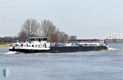
BELLATOR
Other Type
Current Trip
| Time Travelled | 1 day |
|---|---|
| Remaining Time | --- |
| Distance Travelled | 160.75 nm |
| Remaining Distance | --- |
| AVG Speed | 6.1 Knots |
| MAX Speed | 8.2 Knots |
| AVG Wind | 5.6 knots |
| MAX Wind | 7.9 knots |
| MIN Temp | 2.2°C / 35.96°F |
| MAX Temp | 11.2°C / 52.16°F |
| Draught | 1.5 m |
| Position Received | 4 h, 21 m ago |
Current Position
| Longitude | 8.45713° |
|---|---|
| Latitude | 49.30810° |
| Status | Under way using engine |
| Speed | |
| Course | --- |
| Area | North Sea |
| Station | T-AIS |
| Position Received | 4 h, 21 m ago |
Info
Information
The current position of BELLATOR is in North Sea with coordinates 49.30810° / 8.45713° as reported on 2024-04-18 20:17 by AIS to our vessel tracker app. The vessel's current speed is 0 Knots and is heading at the port of MILLINGEN AAN DE RIJN. The estimated time of arrival as calculated by MyShipTracking vessel tracking app is 2024-04-20 07:09 LT
The vessel BELLATOR (MMSI: 205404090) is a Other Type It's sailing under the flag of [BE] Belgium.
In this page you can find informations about the vessels current position, last detected port calls, and current voyage information. If the vessels is not in coverage by AIS you will find the latest position.
The current position of BELLATOR is detected by our AIS receivers and we are not responsible for the reliability of the data. The last position was recorded while the vessel was in Coverage by the Ais receivers of our vessel tracking app.
The current draught of BELLATOR as reported by AIS is 1.5 meters
Weather
| Temperature | 7.7°C / 45.86°F |
|---|---|
| Wind Speed | 4 knots |
| Direction | 257° WSW |
| Pressure | 1020.7 hPa |
| Humidity | 65.7 % |
| Cloud Coverage | 73 % |
Featured Company
Last Port Calls
| Port | Arrival | Departure | Time In Port |
|---|---|---|---|
| 2024-04-16 22:54 | 2024-04-17 04:10 | 5 h | |
| 2024-04-16 10:01 | 2024-04-16 10:13 | 12 m | |
| 2024-04-15 10:34 | 2024-04-15 12:22 | 1 h | |
| 2024-04-14 20:39 | 2024-04-15 08:47 | 12 h | |
| 2024-04-13 11:32 | 2024-04-14 10:10 | 22 h | |
| 2024-04-09 21:53 | 2024-04-10 05:48 | 7 h | |
| 2024-04-09 07:53 | 2024-04-09 21:21 | 13 h | |
| 2024-04-07 17:56 | 2024-04-09 07:24 | 1 d | |
| 2024-04-06 03:00 | 2024-04-07 14:19 | 1 d | |
| 2024-04-04 15:09 | 2024-04-06 01:36 | 1 d |
Most Visited Ports (Last year)
| Port | Arrivals | |
|---|---|---|
| 30 | ||
| 26 | ||
| 13 | ||
| 12 | ||
| 12 | ||
| 12 |
Last Trips
| Origin | Departure | Destination | Arrival | Distance | |
|---|---|---|---|---|---|
| 2024-04-16 12:13 | 2024-04-17 00:54 | 69.58 nm | |||
| 2024-04-15 14:22 | 2024-04-16 12:01 | 94.59 nm | |||
| 2024-04-15 10:47 | 2024-04-15 12:34 | 17.03 nm | |||
| 2024-04-14 12:10 | 2024-04-14 22:39 | 1.96 nm | |||
| 2024-04-10 07:48 | 2024-04-13 13:32 | 186.45 nm | |||
| 2024-04-09 23:21 | 2024-04-09 23:53 | 3.65 nm | |||
| 2024-04-09 09:24 | 2024-04-09 09:53 | 4.13 nm | |||
| 2024-04-07 16:19 | 2024-04-07 19:56 | 22.70 nm | |||
| 2024-04-06 03:36 | 2024-04-06 05:00 | 9.18 nm | |||
| 2024-04-04 09:26 | 2024-04-04 17:09 | 67.02 nm |
Events
| Time | Event | Details | Position / Dest | Info |
|---|---|---|---|---|
| 2024-04-18 20:17 | OUT of Coverage |
49.30810 / 8.45713
North Sea
SPEYER
|
Speed: Course: 511° |
|
| 2024-04-18 20:17 | IN Coverage |
49.30810 / 8.45713
North Sea
SPEYER
|
Speed: Course: 511° |
|
| 2024-04-18 16:55 | OUT of Coverage |
49.30814 / 8.45714
North Sea
SPEYER
|
Speed: Course: 511° |
|
| 2024-04-18 16:55 | IN Coverage |
49.30814 / 8.45714
North Sea
SPEYER
|
Speed: Course: 511° |
|
| 2024-04-18 14:31 | OUT of Coverage |
49.32262 / 8.44931
North Sea
SPEYER
|
Speed: 3.6 kn Course: 176.9° |
|
| 2024-04-18 11:41 | IN Coverage |
49.55314 / 8.41453
North Sea
SPEYER
|
Speed: 6.8 kn Course: 157.2° |
|
| 2024-04-18 09:55 | OUT of Coverage |
49.71349 / 8.40609
North Sea
SPEYER
|
Speed: 6.9 kn Course: 255.2° |
|
| 2024-04-18 04:19 | START Moving | 11.05 nm, West of SCHIERSTEIN |
49.97113 / 7.92753
SPEYER
|
Speed: 3.2 kn Course: 95.3° |
| 2024-04-18 04:18 | Status Changed | Under way using engine Moored |
49.97113 / 7.92699
SPEYER
|
Speed: Course: 511° |
| 2024-04-18 04:13 | Status Changed | Moored Under way using engine |
49.97108 / 7.92667
SPEYER
|
Speed: Course: 511° |